June 25, 2025
Accessibility Improvements
Updated CMS Field Labels for Alt Text and Titles
The CMS field formerly labeled “Description” is now "Alternative Text (Required)" to better reflect its purpose. The "Title" field is now "Media Title," and the redundant text under the alt field has been removed for a cleaner interface.
Clearer Labels on Bus Markers
Improved Accessibility in Wayfinding Distance Unit Controls
June 10, 2025
Feature Enhancements
Accessible Route Selection for Walking Segments in Driving Directions
Users can now choose accessible paths—such as routes with elevators instead of stairs—for the walking portions of driving directions. Previously, this option was only available for walking-only routes. Note: selecting an accessible route may not always change the path if no alternative is needed.
Accessibility Improvements
Improved "Skip to Map" Link Labeling
The accessible name for the “Skip to map” link has been enhanced to provide a clearer, more meaningful purpose for users relying on screen readers
Refined Heading Structure in Maps
The heading structure within the Maps feature now includes a properly assigned <h1> element associated with the logo area. This ensures a logical and consistent heading hierarchy, improving navigation for assistive technology users and supporting WCAG compliance.
Enhanced Sidebar Navigation Labels
We've improved accessibility in the sidebar by adding descriptive labels to <nav> elements. These accessible names—implemented via aria-label, aria-labelledby, or the title attribute (with preference for aria-labelled by referencing visible headings)—help screen reader users understand the purpose of each navigation section.
May 20, 2025
New Features
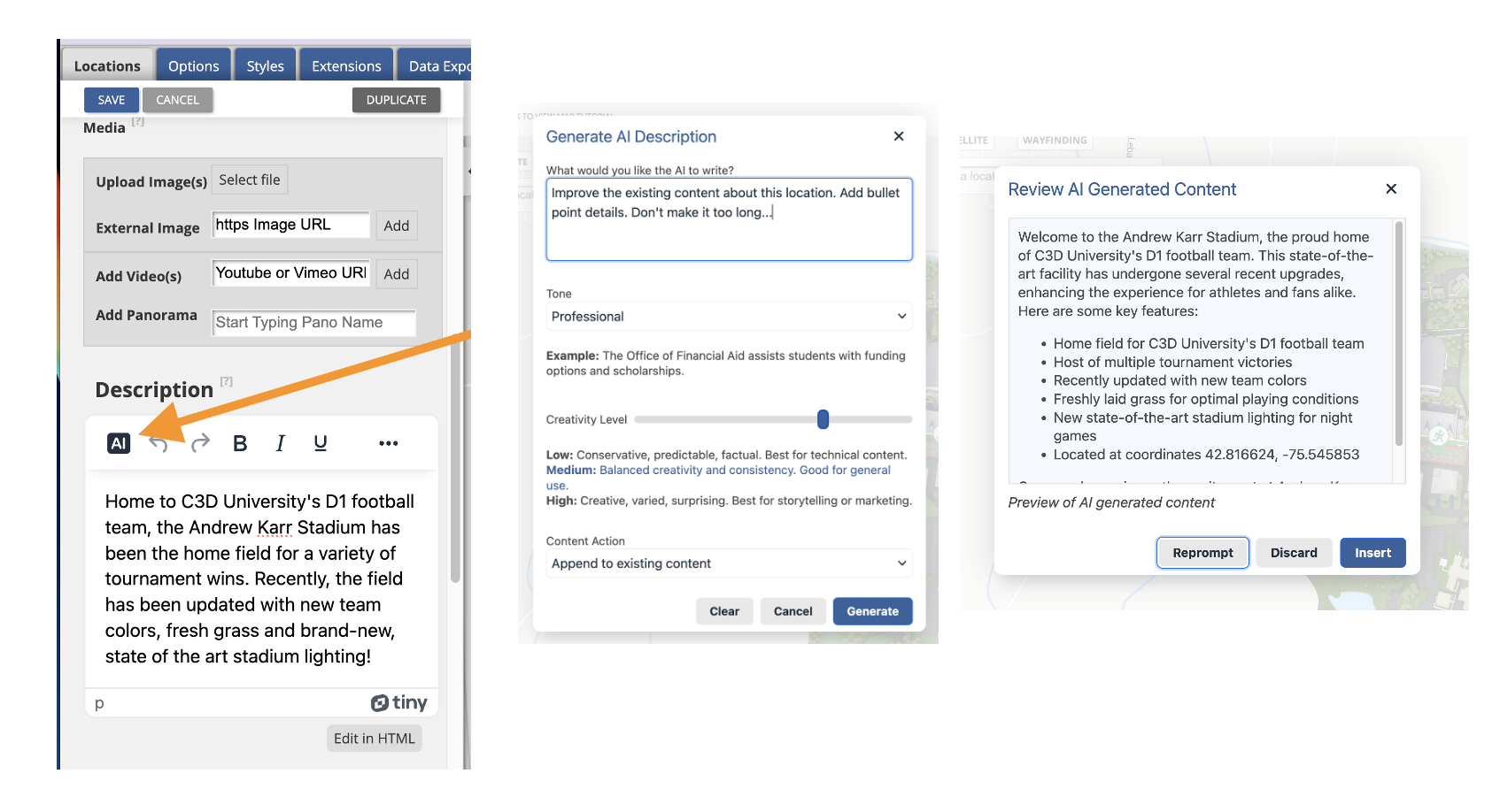
AI-Powered Description Generator for CMS
We’ve added a new AI Description Generator to the CMS that streamlines content creation by saving time and improving the quality and consistency of location descriptions. Whether you're starting from scratch or updating existing content, it helps you craft clear, engaging, and on-brand language with minimal effort.
By automatically pulling in context like the location name and map details, the AI Description Generator reduces the need for manual input. It also supports flexible editing workflows, allowing you to generate, refine, or update content directly within the CMS—making it easier to keep your map accurate and polished.
Key capabilities include:
- Generate AI-powered content for new locations or enhance existing descriptions by replacing or appending text
- Customize prompts to guide the AI in meeting specific content needs
- Use right-click functionality to generate or refine content from selected text
- Adjust the creativity level to control how imaginative or factual the output is
- Choose from eight distinct tone options to match your intended voice
Check out this help article for more information!
May 8, 2025
Ability to Embed Map Locations without the Location Display
- Marker stays visible
- Balloon/sidebar is hidden
- Works on desktop & mobile
- Compatible with other query parameters
- Works well when hiding top bar and sidebar as well for marker only dynamic embeds
Improved Accessibility for 'Show More' Button
Improved Error Message Display in Map CMS
We’ve refined the look and feel of error messages in the Interactive Map CMS. The updated design is less alarming—reduced in size and now shown in orange instead of red—to better match the severity of most issues.
May 1 & 5, 2025
This release brings a wide range of impactful updates across performance, usability, accessibility, and wayfinding. From a smoother CMS experience with better error handling and simplified style management, to more intuitive indoor navigation with level-aware directions, these enhancements are designed to make your workflows faster and more user-friendly. Read on for all the details!
Feature Enhancements
Level Selection for Directions in Multi-Level Buildings
Users can now specify their current floor level when obtaining directions from their current location in multi-level buildings. This ensures accurate navigation within complex interiors. When selecting "my location" as the starting or ending point, users will be prompted to choose their floor only if the building features multiple levels. The floor designation will be integrated into the interface for better usability.
Enhanced CMS Error Handling for Bad Data
We have improved how the CMS deals with bad data to prevent it from crashing when saving revisions. Users will now receive notifications if bad location data is detected. Instead of halting the entire system, an error message with details on the problematic revision will appear, which includes support contact information.
Simplifying Styles Management
Improved Wayfinding Desktop and Mobile UI Alignment
Accessibility Improvements
Easier Keyboard Navigation in Location Sidebar
Better Headings for Sub-categories
Improved “Back” Button for Assistive Tech
April 25, 2025
Enhanced Map Embed Code
Our map embed codes now include permissions for accelerometer and gyroscope. This enhancement activates the blue directional "cone," improving user orientation and interaction with embedded maps. Previously, users experienced an issue where the directional cone was not visible despite having location services enabled.
Note: Any customer who already has an embed code in use will have to update their implementation with these details. It is not retroactive.

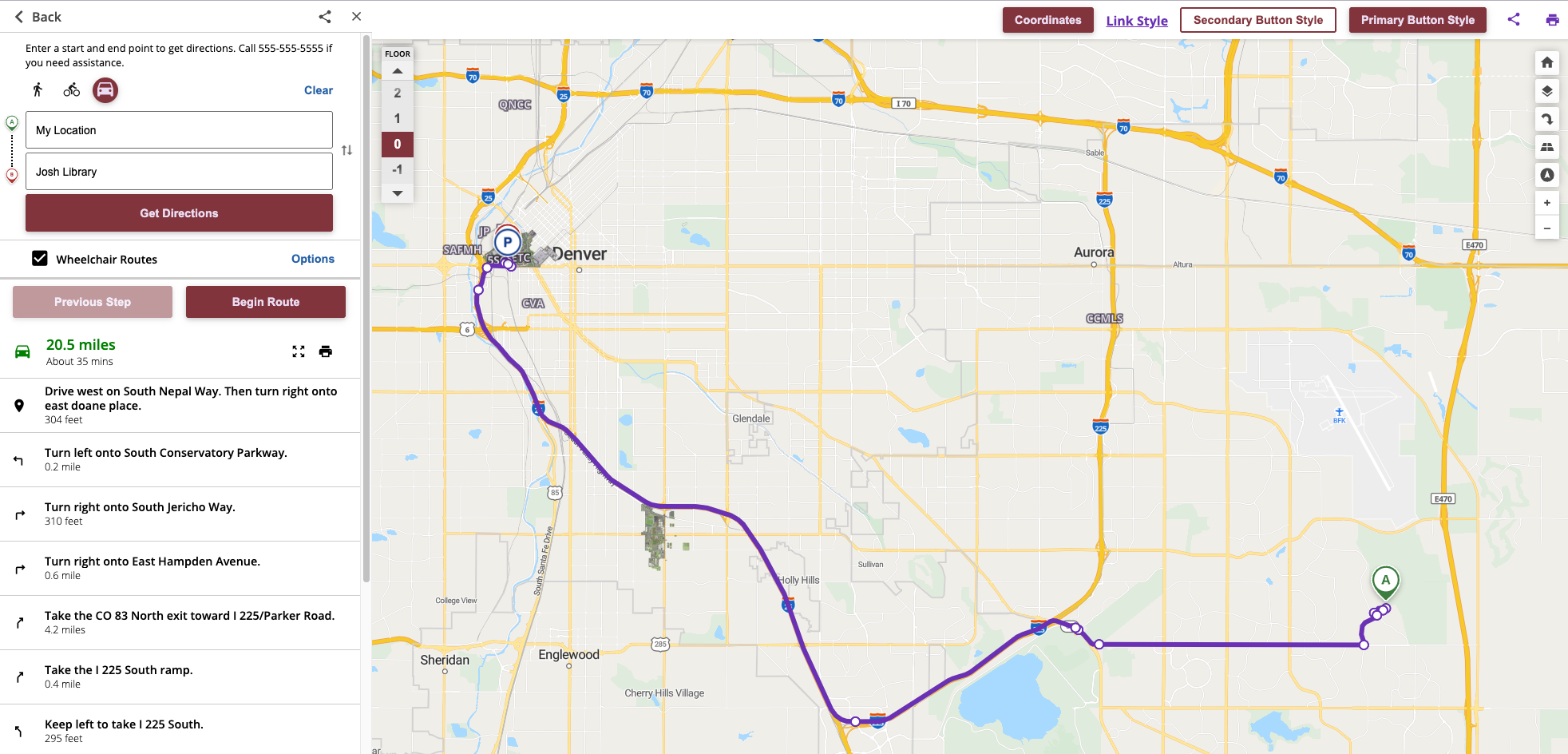
Improved Transition from Driving to Walking Directions
Enhanced the connection between driving and walking directions on our platform. Previously, users experienced a gap between where driving routes ended and walking directions began, often resulting in confusion when navigating campus areas. Now, the transition is seamless and intuitive, providing a more cohesive navigation experience. This improvement ensures that paths link correctly, helping users easily reach their desired destinations from parking areas to campus wayfinding paths.

CMS Performance Improvements
Efficient Loading of Routes Data in CMS: We optimized the Content Management System (CMS) to enhance performance and user experience by loading route data only when the routes tab is accessed. This change significantly reduces initial load times and server load, making it smoother for users. This adjustment also minimizes API calls, helping ensure that the route information you modify or view is as current as possible, and reduces conflicts in concurrent route editing scenarios. Users can now expect better responsiveness of the CMS without the hefty initial data load.
Accessibility Updates
- Improved List Markup for Map Controls: We've enhanced the screen reader experience by ensuring that items such as "Reset map view" and "Open map layer" are correctly identified as lists.
- Accessible Labels for the Level Selector: The level selector buttons now provide clear and descriptive information for screen reader users. Buttons like "View floor one level up" and "View floor one level down" now announce their function properly, ensuring users understand their purpose. Also, we fixed the issue where accessible labels for floor selectors did not match their visual names, aiding screen reader users.
- Improved Mobile Map Attribution for Screen Readers: "Privacy Policy" and "Terms of Service" links are now grouped in a list for easier screen reader navigation. Also, the close button on the map attribution screen is now clearly labeled for screen readers.
- Improved Screen Reader Experience for Skip Menu Links: The skip menu links now correctly instruct screen readers to announce relevant information only, enhancing navigation for users with screen readers.
- Improved Focus Order in Media Gallery Sidebar: We've streamlined the navigation experience by restructuring the focus order of interactive elements in the media gallery sidebar. Now, using the Tab key to navigate will move focus through the "Minimize Location Details," "Share location," "Open directions," and "Close" buttons in a logical sequence. Similarly, the focus order for slides now correctly navigates from "Previous slide" to "Next slide," finishing with the "Fullscreen" button. These changes make the application more keyboard and screen reader-friendly, enhancing accessibility for visually, physically, and neurologically diverse users.

April 9, 2025
Improved Handling of "No Info" Locations in Mobile Map UI
In the mobile map interface, locations marked as "No Info" will now have a cleaner and more intuitive experience. The previously disruptive white bar has been removed and users can easily dismiss these location markers by tapping anywhere off the marker to close them, enhancing interaction efficiency and visual clarity on the map.

Accessibility Enhancements
Improvements to Map Controls
Screen Reader Feedback for Map Rotation: Screen readers now announce changes in view direction when the rotate button is activated.
Pitch Button State Announcements: The map pitch button now communicates state changes to screen readers, enhancing usability for visually impaired users.
Map and Satellite View Tabs: The map and satellite view buttons are now recognized as interactive tabs with accurate state roles. Screen readers can convey their status, and users can navigate between them using arrow keys.
Map Layer and Floor Selector Updates: Status changes in map layer toggles and floor selectors are now announced via ARIA live regions. This ensures screen reader users receive timely updates without requiring manual focus.
Zoom Control: The map's zoom control now includes proper textual names, roles, and state information for screen reader accessibility, ensuring visually impaired users can understand and interact with the slider effectively. The Zoom slider functionality has been removed to ensure a more consistent and maintainable implementation.