December 20, 2024
Map Tours: Directions Button Removed
The directions button has been removed from map tours to improve the user experience, as the current directions did not add significant value when a user is within a map tour and resulted in confusing experiences. This change aims to streamline the map tour experience and eliminate navigation obstacles.
Wayfinding Enhancements
Enhanced Map Pin-Dropping Experience: Introducing an exit option in the map pin-dropping process for improved navigation. Users can now easily exit the flow without generating a route, enhancing ease of use and reducing frustration.
Improved Location Service Warnings: We've updated the way low impact errors are communicated when users deny orientation permission on iOS. Instead of an intrusive error modal, we've implemented a subtle, temporary location dialog that softly advises you of the denied permission, without interrupting your wayfinding experience. This update ensures that you receive important notifications without unnecessary distractions.
Reroute Option for Wayfinding: Enhance your journey with a new option to recalculate your route if you veer off your path. When you stray too far, a “Recalculate” button will appear, allowing you to generate a new path from your current location. The stray distance for prompting a reroute is initially set to 30 meters but can be adjusted via the edit page for more customized path adjustments.
Enhanced Wayfinding Sharing with QR Codes
The Wayfinding share functionality now uses the same share modal as locations, making it simple for users to scan and access directions instantly. This change is very helpful for kiosk implementations.
Accessibility Enhancements
-
Improved ADA Compliance for the Map Footer: The footer, or
contentinfoelement, has been restructured to enhance accessibility. Previously nested within a landmark, it is now positioned independently to comply with ADA best practices, improving access for all users.
-
Enhanced Screen Reader Accessibility for Images in Search Results: We've improved the experience for screen reader users by ensuring that decorative images in search results no longer carry redundant alternative text. Non-meaningful images are now marked correctly, allowing screen readers to skip over them without providing unnecessary information. This change enhances usability and compliance with accessibility standards.
-
Improved Focus Order in Search Results: Non-interactive elements have been removed from the focus order in search results, enhancing accessibility and preventing confusion for keyboard users.
-
Keyboard Navigation Fix in Directions Inputs: Resolved an issue where keyboard focus was trapped within the Directions Inputs, allowing users to now navigate beyond these fields smoothly using only the keyboard.
-
Improved Keyboard Accessibility for Map Control Tool Tips: Map control tool tips are now accessible via keyboard navigation, enabling keyboard users to interact more effectively and access all functionalities without a mouse.
-
Share Modal Dialog Focus on Mobile: Resolved an accessibility issue where the focus did not automatically move to the share screen when on mobile, ensuring proper focus updates for screen reader and keyboard navigation.
November 14, 2024
Style Enhancements for Wayfinding Directions
The Wayfinding step directions container now sports a fresh new look! We've increased the font size of the "End Location" to be more visible and enlarged the overall container for added clarity. Enjoy a cohesive color scheme as the direction container now rocks a matching blue hue with the Next/Previous buttons. Plus, we've underlined the Edit button for a stylish, yet functional touch. Happy navigating!

November 4, 2024
Wayfinding Real-Time & UI Updates
It’s finally here! While there are still a couple follow ups coming to improve the line display and minor UI tweaks, Wayfinding updates can be enabled for any customer.
Key Feature Enhancements
- UI Improvements - more map view
- “Follow me” approach, steps adjust with user
- Orientation follows user (OSM map types only)
- Blue dot snaps to route
- Custom help pop up
- Improved drop pins experience
- Improved error messaging
UI Overview
Generate Route:


Route Summary:

Options and Steps:

Route Navigation Overview & Updates:


Enhanced iOS Location and Orientation Support & Notifications
We've polished up our app's location & orientation alerts for iOS devices, ensuring all those location and orientation features are intuitive and provide necessary help as needed.
Updated Directions Summary UI
The directions summary screen has been spruced up to show both the starting and ending locations, making it more intuitive! We've kept the convenient edit button and streamlined the exit options for a smoother navigation experience. We added some color to the active step direction to help draw attention to it!
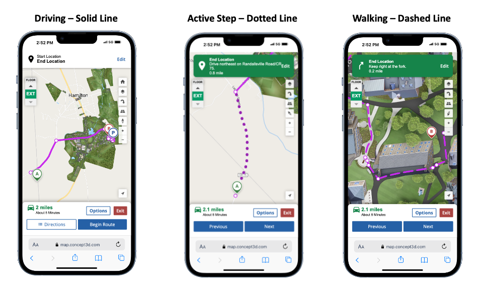
Improved Wayfinding Route Line Display for Walking vs. Driving vs. Active Steps
Walking, driving and active step directions are now easier to tell apart! Walking paths will appear as friendly dashed lines, while driving routes stand boldly in solid lines. Meanwhile, as you are navigating your route, the active step you are on will display as a dotted line, color slightly darkened. Whenever you transition from a walking path to a driving route, the handy marker will still point the way. Enjoy a smoother navigation experience with these visual cues guiding you!
Customize Blue Dot “Snapping Distance”
As part of the new mobile Wayfinding updates, the users location, i.e. “blue dot” will snap to the wayfinding route as they are navigating. Depending on the campus or area, sidewalks may be closer than others. If the blue dot is not aligning well, we can adjust the distance required for the blue dot to snap to place. Right now the default is 20 meters. This is currently a Concept3D Admin field - so work with your client success manager to make adjustments. Happy snapping!
View Category and Marker IDs Effortlessly in the CMS
You can now easily view category and marker IDs directly within the CMS, displayed under the title in a non-editable format on both category and location edit pages. No more going through the URL or tedious data exports to find these IDs when making custom view embeds, dynamic categories or static maps – they’re right where you need them, instantly accessible after publication!

October 15, 2024
Enhanced C3DGL(OSM) Polyline Visibility
We've made significant improvements to the visibility of polylines on the C3DGL (What clients know as the OSM) platform. Previously, these lines were thin, yellow, and dotted, making them difficult to spot. Now, the polylines have been upgraded to be solid and have a thicker line width. They are colored red by default to stand out better against backgrounds, resembling the bold and clear lines you're familiar with on Google Maps.