July 7-8 : Map Release
New Featuresx
Ability to Clear Search
- Interactive Map users can now quickly and easily clear their search terms. Previously, the close button was unclear and users thought it would clear their search bar. Now, there’s an additional “Clear” button in the search bar itself to ensure users know what action they are about to take.
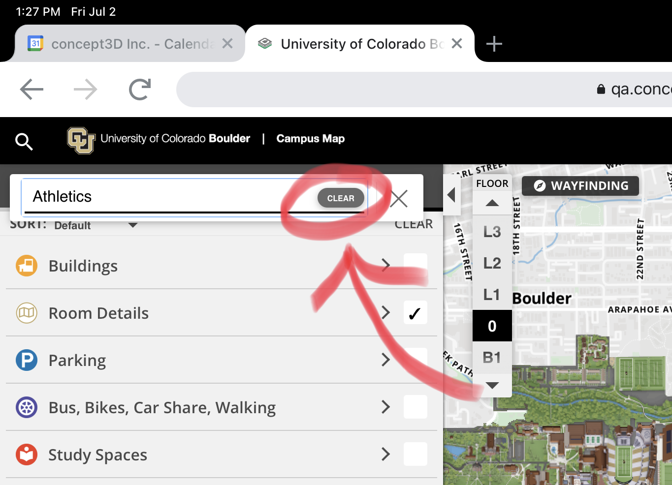
The clear button will appear when the search bar has text inputted.
New Permission: Route Builder
- Admins now have access to a new permission they can add in Roles in the CMS: access to Route Builder. “Routes” will simply enable or disable users with the role from accessing Route Builder in the CMS.
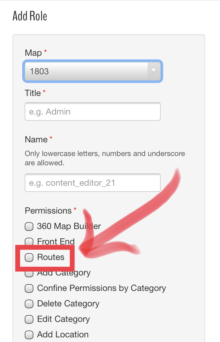
The new “Routes” setting enables users to access Route Builder.
Front End Map Only User Permission
- The Front End permissions in the CMS only applies to users on maps with restricted map access. These users previously still had access to the CMS if they knew where to login. This has been enhanced to ensure users with the “Front End” permission can ONLY login to the front end map.
Ability to Set Location Open to an External URL
- Location Markers have always opened more details about a location, but now they can open to an external URL as well. CMS users can either create or edit locations with a new Location Open option that sets what clicking on the Marker will do. If the “external URL” option is chosen, users will then be able to input a URL (using HTTPS) and set if they want the URL to open in the same or new window. Coming soon… the ability to open load a different map view when selecting a marker (like top bar buttons) as well!
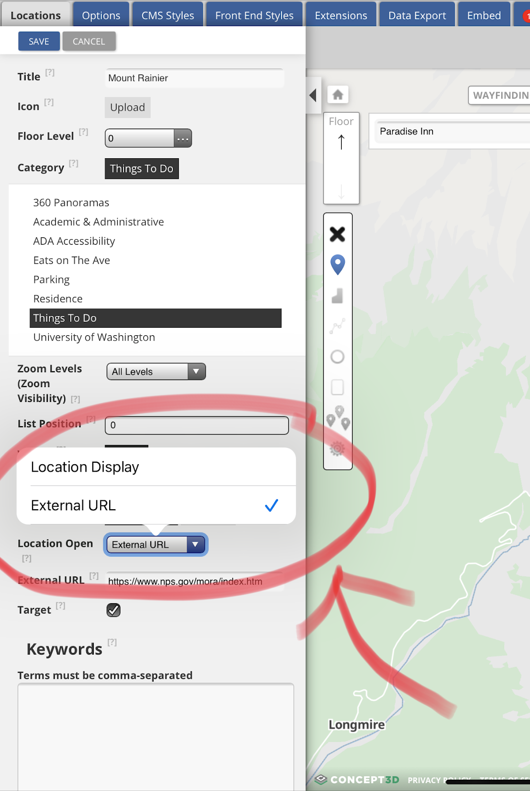
CMS users are now able to decide if they want to a marker to open up the Location details page or link to an external URL.
Google Analytics for Location Media
- Google Analytics has been tracking when Interactive Maps users open the media gallery of a location, but it hasn’t been tracking important information such as the location of the media is displayed in or what type of media users are looking at. There are two updates to Google Analytics to address this:
- The “Explore Media Gallery” Event Action will now also track the location name as the Event Label.
- Event Action called “Image Loaded”, “Video Loaded”, or “Pano Loaded” will track which type of media was viewed in the gallery.
Other Updates
Various Feed Updates
July 20 & 28 : Map Release
New Features
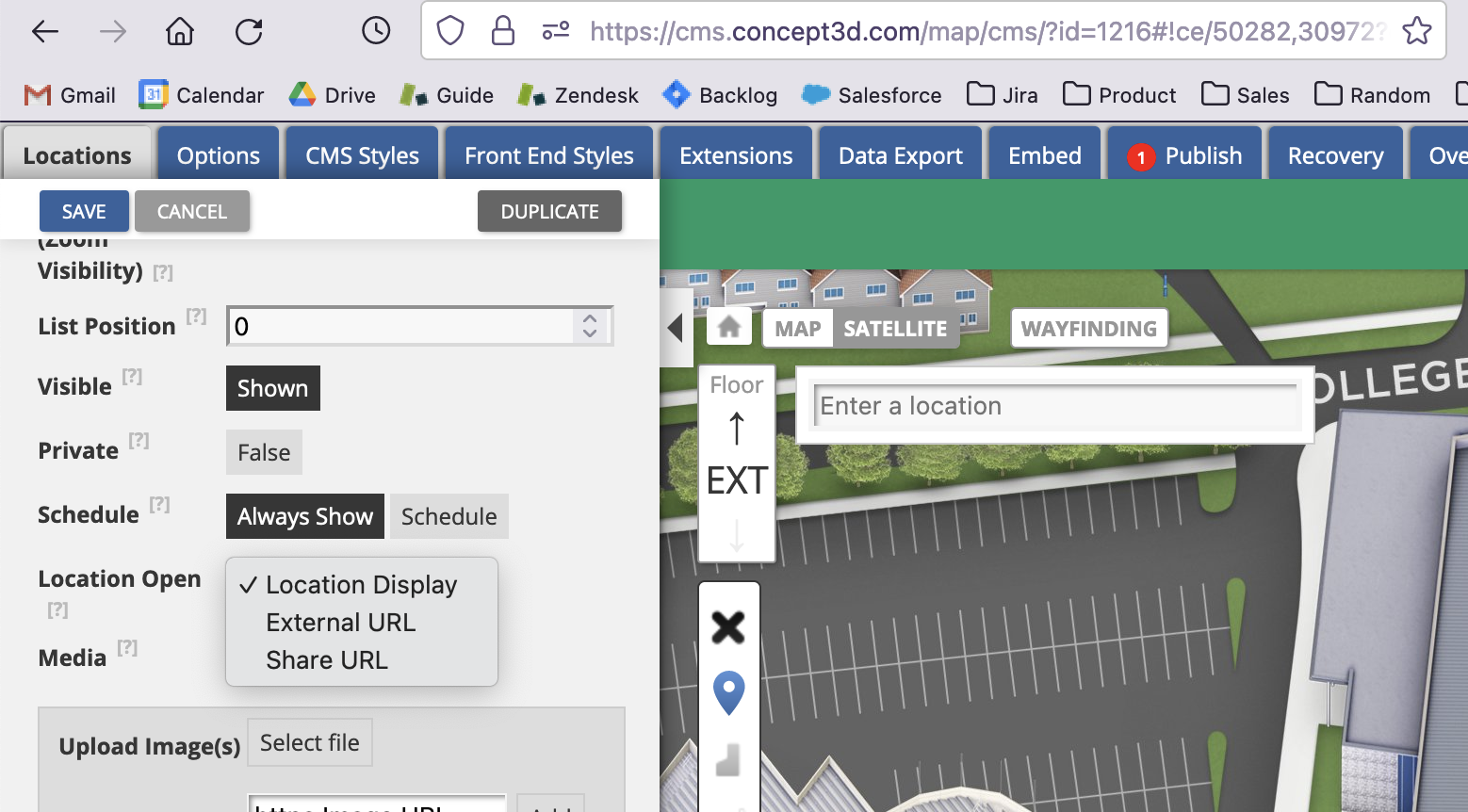
Markers Open as Share URL Feature
- Allowing a location to open a share URL provides CMS users the ability to use a polygon or marker from a higher level view (to indicate a building or an area) and when clicking that marker or polygon, change the map view and load additional locations. This provides more of an interactive/exploratory experience than navigating solely via the sidebar or search.
API Enhancements
Customers are taking advantage of our API for more in depth use cases. Therefore, we have made a few enhancements to help with implementations.
-
Ability to filter locations API call by labels
-
This will allow clients using our API to add labels to locations they want to filter and display the information differently on their front end implementations.
-
This will not impact our current C3D front end map
-
Expose Preview Mode via API
-
API clients may want the ability to view changes in their own environments prior to publishing data. By exposing the preview mode parameter in our API, developers can utilize preview mode in test versions of their applications.
Performance Enhancements to Category/Marker Loading
- An index was added on the marker instance table to improve loading of categories and locations.
Logout Button / Top Bar Added to CMS "You Don't Have Access" Page
- If a user visits the CMS while logged in to a Tour Builder account that does not have access to the CMS, they will receive an error page. This page now has the C3D top bar that displays who they are logged in as. The top bar also has a logout button and a link back to Tour Builder.
August 11-19 : Map Release
New Features
(ADA) Indication of State for Dropdown Buttons and Sidebar
Screen reader users navigating Interactive Maps need to know which interface elements can be opened to closed. The dropdown buttons in the top-bar and the entire sidebar are examples of elements that need this indication. These elements have been marked up correctly now. Screen reader users focusing on dropdown buttons or the sidebar will now know whether the element is opened or closed when they focus on the element.
Other Updates
Various Feed Updates
September 20, 2021 : Map Release
New Features
CMS Ability to See Locations Under “List Type None” Category
- Categories in the CMS have a “List Type None” setting that can be enabled if map managers do not want the category to be expandable on the frontend (meaning you turn on the category without being able to see the drilled down locations). This setting would apply to both the frontend and CMS previously. In the CMS, this made it hard for map managers to see and edit locations under these categories. Now, List Type None only applies to the frontend and map managers will be able to access all locations easily, no matter the category type.
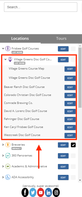
List Type None categories still expand in the CMS.
Filter Out “Out-of-Service” & “Archived” Transit Routes, Vehicles, and Stops for Passio Feeds
- Passio is a relatively new transit provider supported by Interactive Maps. This update improves this newer implementation and removes routes, vehicles, and stops that are labeled “out of service” or “archived”, both of which map users won’t need access to.
Removed Trial Print Map Button in CMS
- The CMS had an old Generate Print Map trial button that would generate old style Print Maps. This has caused confusion for clients thinking of purchasing Print Map as an add on. This button is now removed if Print Map is not enabled for the CMS. If Print Map is enabled, CMS users will be redirected to Print Map 3.0 via the Generate Print Map (non-trial) button.
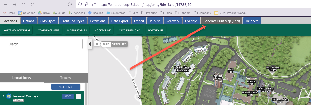
The deprecated Generate Print Map (Trial) button is no longer needed with Print Map 3.0.
Order Transit Routes List Alphabetically
- All transit providers (Transloc, DoubleMap, RideSystems, Synchromatics, and Passio) will now order their routes in the Transit tab alphabetically.
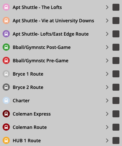
Transit routes display alphabetically for all Transit providers now.
Improve Output Quality of Labels on Print Map 3.0
- Print Map 3.0 fundamentally changed and improved the way Interactive Maps generate Print Maps for clients and end users. However, depending on the zoom level of the selected map area to print, the labels available on the map could be blurry or unreadable. This update addresses that and improves the readability of Print Map 3.0.
Building labels appear much clearer in closer zoom levels now.
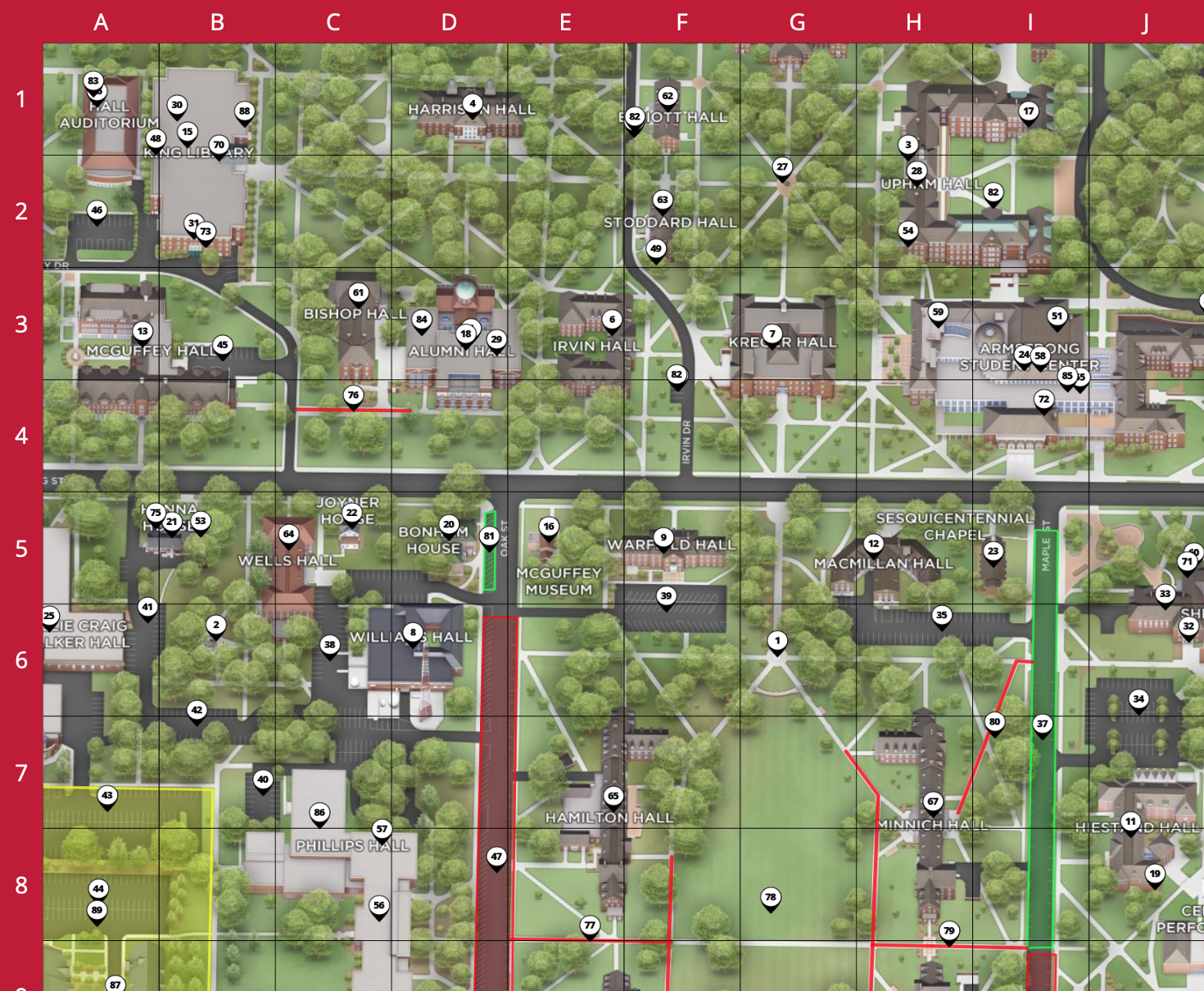
Show Category Overlays on Print Map
- Overlays are often tied to a category on Interactive Maps. However, even when this category was selected as part of a generated Print Map, the overlays were disregarded. Print Map 3.0 now accounts for category overlays and will print the overlay within the selected area.
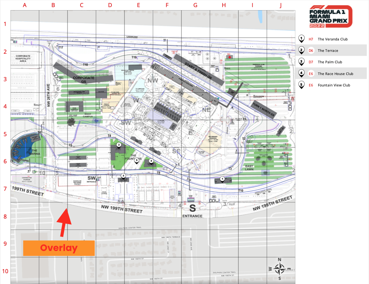
An example Print Map with overlay printed.
(ADA) Error Notification for Incorrect Map Tour Form Input
- Map Tours have Forms that have text fields that can error out if users input the wrong type of information. For example, if a user enters a phone number into an email field. Previously, the only notification that the input was incorrect was a red line that appeared underneath the text field. There are a few issues with this: screen reader users might not be able to see that red line, and they don’t necessarily know what exactly is wrong with their input. An error message has been added to text fields that have specific requirements and will display as needed.
(ADA) Add Navigation Landmark to Sidebar
- Screen reader users often use headings and landmarks to quickly navigate a website. However, this relies on the website using the correct markup and landmarks in the relevant elements. Interactive Maps use navigation and region landmarks already for the keyboard skip links and map respectively. Now, the sidebar also uses a navigation landmark since it is one of the primary ways users can navigate the map.
Other Updates
Various Feed Updates
September 28, 2021 : Map Release
New Features
New Bulk Import Button in CMS
- To help clients more efficiently import their locations, the bulk importer tool is now available via a new Bulk Upload button in the CMS.
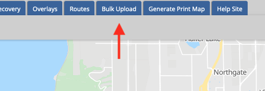
The new Bulk Upload button in the CMS activates the bulk import tool.